This scenic route is a family favorite to explore the area north of Republic, historical ranching and gold mining areas where you can drive right through the old gold fields and past current mining operations, such as Kinross Gold’s K2 mine, and get amazing mountaintop views just outside of Curlew, and finish the day with a great lunch at Tugboat’s in Curlew and stay at the Curlew RV park. Or, head south to Republic where you’ll find motels, RV parks, restaurants, the Stonerose Fossil Center, a museum, stores, and more! Dispersed camping is also available at no charge on Colville National Forest lands in the Empire Lakes region just west of Curlew. In warm weather, you can even float the Kettle River!
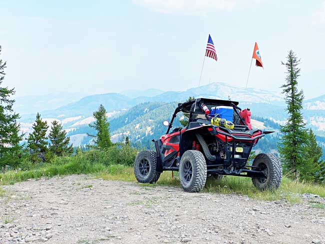
Our favorite starting point is to park in the large gravel parking lot at Tugboat’s Restaurant, at the intersection of SR 21 and Kettle River Road. If you’re staying in Republic, however, OHVs are legal on city streets, so a long day’s ride starts in town, then out Knob Hill Road through the old gold fields, then north on Trout Creek Road to Tonata Creek Road (USFS #2148), following it north to Kettle River Road – head east and you’ll end up at Tugboat’s! An easy loop route starting from Tugboat’s Restaurant proceeds south on SR 21 to the Lundimo Meadows Road intersection, where you’ll turn west/right. OHVs must follow a different route here: OHVs must cross SR 21 on Kettle River Road, turn right/south on Curlew School Road, then proceed into the school parking lot – look for an opening in the concrete Jersey barriers and turn into an OHV path, the Tiger Trail, approved by Ferry County and the Curlew School Board and constructed by local volunteers and members of Tri-County Motorized Recreation Area. This trail parallels the non-motorized Golden Tiger Pathway, crosses SR 21, and proceeds on the right/west side of the county right-of-way alongside the non-motorized trail to the intersection with Lundimo Meadows (look for a path on the grassy bank with a small sign) – once you reach the next road intersection, turn right on Lundimo Meadows Road. Not far south of Curlew, you’ll turn right onto Franson Peak Road and continue to the summit on a gravel road that’s best for high-clearance vehicles (4WD required in wet or snowy conditions; road isn’t maintained for winter use by wheeled vehicles). There are 360-degree views with Canada only a few miles away with snow-capped mountains in the distance most of the year. Please respect the private property of the electronics towers and antennas, but do visit the old fire lookout that’s still on the summit – be careful as this building is in disrepair.
Returning to Lundimo Meadows Road from Franson Peak, if you’d like to do a longer loop, continue to the Empire Lakes Road intersection (USFS # 2150) and head south past Empire Lake to the intersection with Tonata Creek Road (USFS #2148), turning north/northwest. Watch for the turn to Bodie Mountain if you’d like some great views of the mountains to the west – take USFS #2148100, a very steep climb to the towers at the summit of Bodie Mountain, suitable for high-clearance vehicles and OHVs, but not for anyone who isn’t fond of steep drop-offs along the one-lane, rocky road (4WD required in wet or snowy weather; not open to wheeled vehicles in the winter). Once you’ve had your fill of the amazing views from Bodie Mountain, go back down to Tonata Creek Road (USFS #2148) and head north to Kettle River Road, turning east/right towards Curlew. The Ranald McDonald memorial site is right on the road and makes an educational stop for the family – plus, look at the cliffs to the north to see mountain sheep! Continue east along the river and you’ll pass 2 commercial mining operations run by Kinross Gold – they’re still under current claim so visitors aren’t allowed, but the local geology is similar along the river so rockhounds can enjoy looking at the rocky cliffs along the way. Finish at Curlew, and either have lunch here, or head to Republic for a great finish to a long day’s ride! There are lots of other area attractions and roads open for motorized recreation, but OHVs are limited – check the current Colville National Forest’s Motor Vehicle Use Map (MVUM) or use the Avenza mapping app to find approved OHV routes in this area. Canada’s just a few miles up SR21 for international travel if you prefer! For those riding OHVs in the Republic area, remember that outside city limits, state highways aren’t open to OHVs, so you need to use city roads or the Golden Tiger Pathway to reach local RV parks such as the Fairgrounds and Winchester RV Park.