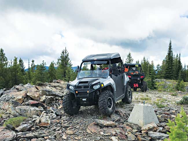
Ferry County has six Jeep trails for both motorized and non-motorized recreation enthusiasts, providing amazing scenery, challenging terrain, and great overall recreational value for the minimal investment of a short drive to the trailhead! One of the area’s favorite trails is Twin Sisters, located east of Albian Hill Road and north of Deadman Creek Road.
The Twin Sisters Jeep trail has both west and east trailheads, but the trail is decidedly different depending on which way you use the trail – it’s more difficult when used from east to west, so many people prefer to start from the western trailhead off Albian Hill Road. If you’d like a safe and simple introduction to the trail, a great route is to simply drive from the west trailhead to the halfway point, the summit of Twin Sisters peak, then return, avoiding the steeper, rockier east end of the trail. The summit lookout site is the main highlight of the Twin Sisters trail: from the eastern starting point at 4.4 miles, or from the western starting point at 4.7 miles, there is a turn off that leads in a northerly direction for approximately .97 miles to a parking area below the peak for amazing 360-degree views!
To use the west trailhead, from the Noisy Waters service center at the Columbia River Bridge on Hwy 395, turn left on Hwy 20, and proceed 18 miles towards Republic. Turn right on Albian Hill Road and proceed approximately 4.7 miles to the Twin Sister/Mack King trailhead area. Currently, Albian Hill Road is not authorized for OHV travel, so OHV users must park at the trailhead area to use either Twin Sisters or Mack/King Jeep trails. OHVs are also not currently allowed on the west end of Deadman Creek Road, so plan on making a round trip either by returning on Twin Sisters Jeep trail, or using the Mack/King trail to make a loop route – be aware that the Mack/King trail is much more difficult than Twin Sisters, especially the eastern end of the trail where this is significant trail damage due to off-road travel that knocked boulders onto the trail, erosion from rain and heavy trail use causing wash-outs, tight switchbacks, and very off-camber and steep slopes.
If you’d like a bit more of a challenge, running the Twin Sisters trail from east to west gives you some steep slopes, off-camber areas, rocky boulders and ledges, and a challenging entrance route! To reach the east trailhead from Kettle Falls, go west on Hwy 395, across the Columbia River Bridge, turning right on Hwy 395 at the Noisy Waters service center. Travel approximately 6 miles, turning left onto Deadman Creek Road. Proceed up Deadman Creek Road for approximately 4 miles to the “Y” where Deadman Creek Rd forks to the left. Anderson Road is on the right. Continue on the left for 2.3 miles to the parking/camping area known as Cow Camp. From Cow Camp proceed another 2.3 miles up Deadman Creek Road to the USFS Road #800, turning right and proceeding another 8.5 miles to the USFS Road #822. This leads to a quarry area where the trail climbs a difficult path on the north side of the quarry to the trail. This is not recommended for novice riders or those with ATVs or smaller OHVs. For a safer, easier access, continue up the 800 Road another 1.5 miles, turning left on USFS Road #840. This will lead a short distance to a berm, which is designed to keep full-size rigs from accessing the trail. Cross the berms to access the Twin Sisters trail in approximately 2.5 miles from the 800/840 road intersection – turn right onto the Twin Sisters trail at this t-intersection.
Twin Sisters Jeep 4WD trail is of medium difficulty for experienced riders. Most obstacles on the trail can be bypassed, but offer fun challenges if you’re a seasoned trail driver! This trail is a jeep trail – OHV’s up to 72” should be able to transit. This trail is cleared on a periodic basis by contractors for the USFS and the Tri-County Motorized Recreation Association, but be prepared for any trail blockages or obstacles – bring saws, emergency gear, and vehicle maintenance tools.
The Northeast Washington Sustainable Tourism and Recreation Team (NEWSTART) has facilitated an all-hands, all-lands coalition of land managers and trail advocates that are working on a strategic plan for trail development and stewardship in our region, including motorized trails.
If you recreate on the trail in Northeast Washington, NEWSTART would love to know what you think needs to be considered in the Trail Strategy.
Please take the comprehensive, 20-minute survey by visiting the website below. We appreciate and value your input!